WELCOME

Hi, my name is Matt Baker.  Welcome to my Blogger site entitled "Journey to PPL"!

That's not a picture of me by the way, although I'll probably look like that when I become a pilot  :-) 

For as long as I can remember I've had an interest in aviation.  As a young kid, my Dad arranged a joy flight for myself and my brother and sister.  Although it was some time ago and I have very vague memories of it, Dad tells me I really enjoyed it and couldn't stop talking about the flight on the way back home  :-)

In more recent years this enthusiasm has escalated and I've re-discovered that passion for flight.  Everyone has a different reason in wanting to learn to fly.  For me its a combination of controlling a technically advanced machine in a procedural way (my IT background coming out) with the freedom of navigating cross-country anywhere you like and enjoying beautiful scenery from a unique perspective.  It presents a mental challenge while satisfying my desire to explore.

Although I'm not one for keeping a diary, I plan to document this journey towards my goal of achieving a Private Pilot Licence (PPL) for two reasons:
  1. Allow me to reflect on my progress and what I have achieved.  I hope it acts as a record of what I've learnt and should provide a good review reference.
  2. Hopefully help/inspire anyone out there who is considering flight training or currently in process of flight training.  If this is you, I hope you may pickup some tips and likewise I hope to do the same from people out there going through a similar training process.
Where available, please feel free to leave comments on the blogs.  I appreciate your feedback and advise.

My blog posts are listed on the Home page in reverse order, ie most recent blog entries are towards the top of this page with the oldest down the bottom of this page.  This is so you can quickly scroll to the latest post under this welcome post.

So if you want to follow my journey from the start, scroll all the way to the bottom of this page and keep clicking OLDER POSTS until you reach my first post entitled "Search for a Flight School".  Then read each post upwards, enjoy!

Thanks for visiting and please drop by again soon as this site will be updated regularly as I progress through flight training.

Cheers!
Matt  :-)

11/10/14: Cross Country Flight Test (Dual): Inglewood

Cross country endorsement flight test!  :-)

I was originally booked to do my Cross Country flight test on 4th October, however there were a couple of little setbacks.  First there was a delay with the refuel truck... after waiting for him to arrive and fill up the aircraft, he finally arrived saying he'd run out of fuel.  We could wait a while longer or as we decided, to just taxi to the fuel bowsers. 

So the CFI and I jumped in Cessna 24-8511 ready for my flight test return to Inglewood, but the engine sputted and wouldn't start?  After a few attempts we couldn't get it started.  A couple of the other Instructors joined us and had multiple attempts without any luck.  They opened the cowling exposing the engine to have a look for anything obviously wrong... looked fine.  By this time it was getting late in the afternoon so even if we got it started, it may be a struggle to get back before end of daylight.  Plus we both were not comfortable flying the aircraft with the engine in this condition, even if we could have got the engine started.

No big drama... I'd rather be on the ground wishing I were up in the sky than the other way round  :-)  Cross Country Flight Test re-booked for next Saturday 11th October.

Saturday 11th October came around quickly.  Cessna 24-8511 had been repaired and was ready to go  :-)  The issue was basically an incomplete seal in the carburettor that had been there since factory.

All flight planning done with a saved flight plan on NAIPS completed in previous days leading up to the flight test.  So on arriving to Archerfield, all I had to do was my pre-flight inspection, complete and submit my flight plan and head off  :-)

My flight plan today:  YBAF - LOGAN - Boonah (YBOA) - Inglewood (YILW) - Boonah (YBOA) - PKR - YBAF

Cross Country Flight Test (Dual): YBAF - LOGAN - YBOA - YILW - YBOA - PKR - YBAF
WAC chart showing nav route
I selected Boonah as a heading change point on the LOGAN - YILW leg to avoid active Amberley restricted airspace.  I knew with prior planning R620B was active during my planned flight time however R620D may or may not be active.  Checking NOTAM told me R620D was de-active for the duration of my flight.

The active today was runway 04R (grass/dirt strip) for my Southern departure off downwind leg tracking to Logan Village.

Coming off crosswind leg and mid-way on my downwind leg, Archer Tower called to advise I should have departed off crosswind leg tracking 135 degrees.  Whoops!... I know the 135 track is taken from the centre of the aerodrome so was planning to pickup the 135 track mid to late downwind leg runway 04R.  I should have come off crosswind leg, flown to the Logan Motorway & Mt Lindsey Highway crossing then picked up my 135 track to Logan Village.  I'd never done a Southern departure off runway 04R but that's no excuse  :-)

YBAF Southern departure (to LOGAN) and arrival (from PKR)
YBAF Southern departure & arrival - zoomed
On the way to Logan Village, I radioed Brisbane Centre to confirm R620D status - de-active.  Cool, I would fly via Boonah.  If R620D was active, I would fly to Inglewood and back via Rathdowney as you can see this contingency on my WAC chart.

Over Logan Village, I turned onto track for Boonah.

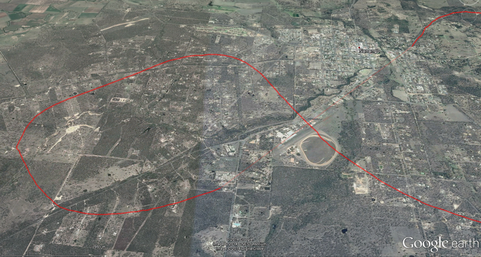
Past Boonah due to cloud level, I wasn't able to maintain my planned cruising altitude of 6500ft, so bought it down to 4500ft.

Using Boonah airstrip as my heading turning point to/from YILW
I arrived to Inglewood, checked windsock and made a mid-field crosswind join for a runway 05 touch-and-go.  I departed Inglewood off the upwind leg, turning right towards my track outside the circuit at over-fly height.  Whoops! I made the same departure mistake I did at Archerfield.  I flew back with Inglewood airstrip on my right wing planning to turn and pickup my track from about the runway mid-point.  You can clearly see this on the Google Maps GPS track.  In hindsight, I should have turned right about another 20 degrees to my track off the upwind leg, flown that heading for a little bit then turned onto my planned heading.  Basically I'm trying to be too precise about it  :-)

Arrival and departure YILW
Arrival and departure YILW - zoomed

Flying back to Park Ridge via Boonah, I needed to do a 1-in-60 as was just left of track at Lake Moogerah.  Past Boonah I picked up the Mt Lindsey Highway and spotted Park Ridge tower, my South inbound reporting point for YBAF.  Past Boonah was largely a visual part of the leg.

Archer Tower gave me instructions to join final runway 04R.  Landed, parked and flight done!  :-)  Feedback from the CFI was all my navigation, checklists, briefs and radio work were great.  My revised estimates and ATA were within a minute so happy with that.

Passed my Cross Country endorsement flight test!!  yay!  :-)

Passed!!  :-)
There's always room for improvement and lessons learned, so a couple of things I take-away from this flight:

- In flight, maintain altitude better
- Don't over complicate departures to pickup track
- With flight planning, use two time checks per leg which only works on straight legs.  In this instance I was lucky it worked ok as it was a short distance between Logan Village/Park Ridge and Boonah.

So where to from here?  Enjoy my new RA-Aus endorsement and look to transition to the CASA Recreational Pilot Licence (RPL)... stay tuned in the coming weeks...

Until next time, have fun and fly safe!  :-)

20/9/14: First passenger

I've since received my RA-Aus passenger carriage endorsement... a stamp in my log book from the CFI to say I meet the minimum solo flight hours to qualify for this endorsement.  I've now got a new pilot certificate with another endorsement added... "PAX".  Cool  :-)

However for the immediate future at least, CASA have introduced a "clause" onto the exemption that Pathfinder Aviation have regarding operation in and out of Class D airspace.  It basically says we as RA-Aus Pilot Certificate holders with passenger endorsements flying RA-Aus registered aircraft can't fly with a passenger during towered hours, i.e. between 7am-5pm.  So this time of year, that gives me a window between about 5.15am - 7am to be up and back with a passenger.  Flying between 5pm-5.50pm would be cutting it a bit fine and there is a risk of landing later than 10 minutes before end of daylight. 

My understanding is CASA have basically now clarified the term "solo" meaning the only person in the aircraft and not meaning without Instructor but with a passenger.  The Recreational Pilot Licence (RPL), CASA's version of the RA-Aus Pilot Certificate, is apparently not far away and I think won't have this restriction around passenger carriage.  It should be a relatively easy transition to the RPL from my current licence.  No worries, time will tell as things are sorted out (please correct me if I'm wrong on any of the above)...

Now for my first willing passenger...  :-)

I thought it should be a family member so offered a flight to my Dad.   Dad said he would love to go up with me  :-)  As this would be a 6am departure, Dad stayed over at our place on the Friday night as this would save him a long commute quite early in the morning.  I live about 10 minutes drive to Archerfield airport which makes it easier.

So Saturday morning we're up at 4.30am arriving to Archerfield at 5am.  Haven't done a first flight of the day for a while  :-)

While Dad made himself comfortable in the passenger lounge, I completed some paperwork and did the aircraft pre-flight inspection.

Next came the passenger briefing... some I did in the terminal building and the rest in the aircraft before startup.  Here's the checklist I've written to cover the passenger brief based on the CAO requirements:


Terminal BuildingAircraft
Flight path on chartExplainedSupervise on apronCompleted
What expect in flightExplainedDoor open/close/ lockDemonstrated
Sterile cockpit takeoff/landingExplainedBoard/exit aircraftDemonstrated
Carry dangerous goods?AskedSeatbelt use/ adjustmentDemonstrated
Apron safety/ hazardsExplainedHeadset use/ volumeDemonstrated
Toilet before flight?AskedNo smokingExplained
Any questions?AskedStowage of hand luggageExplained
  Air sick bagsExplained
  Air ventsExplained
  Keep hydratedExplained
  Traffic scan/notifyExplained
  TalkingExplained
 Emergency procedures/exitsExplained
  First Aid kitExplained
  No touch controlsExplained
  Relax & have funExplained
  Any questions?Asked


As I don't have all this committed to memory, it just makes sure I don't miss anything important like going to the toilet before flying  :-)

Starting the GoPro video just before doing passenger brief

Briefing done and taxied to the runup bay for the usual checks.  Winds were calm so the active is runway 28R.  We took off 5.45am for a departure to the East for the training area off the left downwind leg (28R is left turn circuit outside tower hours).  All radio calls are standard CTAF broadcasts as Archerfield becomes uncontrolled airspace outside of tower hours.

First passenger flight within Eastern training area

I continued my track straight out to the Eastern side of North Straddie pointing out some ground features along the way.  Reaching Straddie, I banked right following the beach, dodged a low cloud and came back inland past Jacob's Well.  I did a series of slow left and right turns around the area giving Dad plenty of photo opportunities.

Flying in the Eastern training area

Keeping an eye on the time, I commenced my descent and tracked back towards Archerfield via Target VFR reporting point.

I saw no other traffic and didn't hear anyone on the Archerfield CTAF, so made my inbound call with intentions for a straight-in approach runway 28R with a followup 3nm final straight-in approach call.

We landed and taxied back to the apron for parking.... a very happy first passenger!  Plus its Dad's birthday next week so was an early birthday treat  :-)

Archerfield departure and arrival
Me and Dad (very happy passenger) after landing

Until next time, have fun and fly safe!  :-)

13/9/14: Cross Country Navigation #8 (Dual): Nanango and Caloundra

Another awesome day for flying around SE Queensland!  :-)

As this navigation exercise was scheduled for a 11.30am departure, I downloaded the weather forecast (ARFOR, TAFs and METARs) the morning of the flight.  Now I had forecast winds, I completed my flight plan at home and arrived at Archerfield about an hour early to prepare for the flight.

Mick, the CFI would be going up with me today so at first I thought this was going to be my cross country endorsement test, but it was another navigation exercise with an Instructor.

Nav #8 (Dual):  YBAF - DBO - YNAN - YCDR - DBO - YBAF

WAC chart showing nav route

A Northern departure from Archerfield off runway 10L saw me tracking initially towards the Walter Taylor Bridge (Indro bridge) and then onto Dayboro ensuring I remain West of Mt Cootha and clear of Class C airspace to my right.

Dayboro - Northern arrival & departure tracking point

The first leg Dayboro to Nanango went well with my arrival joining mid-field crosswind and at Instructor request, a low pass along the airfield (go-kart track right next to the airstrip!) before departing off the upwind leg.

Nanango airstrip (YNAN) showing flight track
Nanango airstrip

Tracking East towards Caloundra, Mick showed me some GPS features of the Garmin G300, which when the Directional Indicator is paired with the GPS, it acts similar to a VOR.  Cool stuff  :-)

Approaching Caloundra with its cross runways, I selected runway 12 (right turn circuit) based on reported surface winds and elected to join right base for a runway 12 touch-and-go rather than a straight-in approach.

On joining base, on the area frequency we heard a pilot above us reporting he was about to drop some skydivers around the Caloundra area.  My Instructor replied back advising we were already in the circuit for touch-and-go and asked for more details including ETA for drop... 1 minute!  Ok, quick touch-and-go and lets get out of here  :-)  I departed Caloundra by extending the right crosswind leg off runway 12 tracking back towards Dayboro.

Caloundra aerodrome (YCDR) showing flight track
Caloundra aerodrome

Past Dayboro heading South I tracked West of Mt Cootha, checked Archerfield ATIS, radioed Tower and reported position again at Centenary bridge for circuit joining instructions.  Join final runway 10L.  I overshot my turn onto final for runway 10L so made a sharp bank left to pickup my runway line... whoops!

Archerfield Northern departure & arrival

Landed and taxied back to the apron.  Mick advised basically not to overthink things too much, keep it simple and watch my altitude... keep it consistent.

Next navigation flight 4th October will be my cross country endorsement test!  :-)  YBAF - LOGAN - YILW (Inglewood) - PKR - YBAF

Until next time, have fun and fly safe!  :-)

6/9/14: ETA & YBAF circuits in C162


I guess there was a mix up or mis-communication somewhere as my next navigation flight scheduled for 30th August wasn't in the system. No problem, the next date when both my Instructor and I were free for a navigation flight would be 13th September.

So in the meantime, given there would be a few weeks gap between flights, I booked in some solo time in the Eastern Training Area (ETA) and circuits in the Cessna C162 Skycatcher.

Another beautiful day in Brisbane... great for flying  :-)

I arrived to Archerfield, signed the aircraft out, completed pre-flight inspection and departed East for the designated training area to brush up on some piloting skills.

ETA & YBAF circuits

Coming back into Archerfield via Target (East inbound VFR reporting point), I requested circuits on arrival.  Tower gave me instructions to join downwind runway 10L for circuits.  Normally, Tower clears you for a join downwind runway 10R then will change you to runway 10L when making your downwind call.

I completed 5 normal touch-and-go circuits and headed back to the Eastern apron for parking.

YBAF circuits - runway 10L
Until next time, have fun and fly safe!  :-)

8/8/14: Cross Country Navigation #7 (Dual): Warwick and Casino

As the Archerfield to Warwick leg of this cross country flight passes through Amberley restricted airspace, I needed to plan a diversion for this leg to avoid the airspace should it be active at the time of flight.

Leading up to the 8th August, I called the Amberley number listed against airspace R620B and R620D (as per ERSA) to ask for the likely status of this airspace on the date/time of my planned cross country flight.

Amberley got back to me advising the likely non-active times but to confirm with NOTAM (which I do anyways when obtaining the weather forecast) and contact Brisbane Centre in flight to check live status (which I had planned to do).  They also offered airspace transit if I contacted Amberley Clearance, although this means they would give me a transponder code and probably divert me around the place.  Not the best solution for a cross country navigation exercise.

So in my flight sequence steps done during flight planning, I noted at what point in the YBAF - YWCK leg I would contact Brisbane Centre to check Amberley restricted airspace status and at what point I would divert should the airspace be active.

It turned out the airspace was active, so my Instructor asked me to divert to Warwick.  This was relatively easy as I had done all the pre-work (heading, distance, etc) during flight planning  :-)

Nav #7 (Dual): YBAF - LOGAN - YWCK - YCAS - PKR - YBAF
In the GPS track above, you can see the turn left not too far after Logan Village to track around Amberley restricted airspace.

Cloud was low and scattered making it difficult for me to see ground references.  Warwick out to my right was clear although I was looking for a particular highway to mark as my turning point towards Warwick.  I basically followed the reciprocal heading for the Warwick departure.

We did a full stop landing at Warwick for a quick break and then onto Casino. 

Warwick aerodrome
Warwick aerodrome

Half way through the YWCK to YCAS leg, I started to slowly drift to the right meaning as I approached Casino it was not in front of me as expected, but to my left!  I wasn't aware of the drift in flight as the actual winds were stronger than the forecast winds.  I did a touch-an-go at Casino and tracked North back towards Archerfield.

Some weather was ahead of us preventing me from maintaining my planned heading and altitude.  This is where I messed up a bit by thinking about my options too long and not taking action quickly enough.  I knew what my options where but I failed to verbalise my decision to the Instructor.

To avoid the weather, my decision was to essentially do a diversion for this leg using pilotage and fly through the valleys North of Kyogle where I could see gaps in the weather.  The unexpected diversion threw me off a little and it took me about 7-10 minutes to correctly locate my position on the charts.

Another cross country flight with things I did well and things not so well... always learning  :-)

Both my Instructor and I agreed it would be best I do another short cross country flight before going for the test.  I certainly feel I need it. 

All I can do is learn from Instructor feedback and ensure I put it into practise for future flights  :-)

My next cross country flight is Saturday 30th August doing a Northern route this time (its been a while) - Archerfield to Nanango to Caloundra to Archerfield.

Until next time, have fun and fly safe!

12/7/14: Cross Country Navigation #6 (Dual): Lismore, Grafton and Stanthorpe (diversion to Park Ridge)

Sorry its been a while since my last blog post!  :-)

Continuing to work towards my RA-Aus Cross Country endorsement, I've completed a couple more cross country flights since my first cross country solo back on 15th June.

The first one was on 12th July - a Southern departure from Archerfield tracking to Lismore, then Grafton, onto Stanthorpe and a Southern arrival back to Archerfield.

Today's flight is like a pre-test assessment cross country flight with an instructor.  All going well and if the Instructor feels I'm ready, my next flight with be the Cross Country endorsement test.

Nav #6 (Dual): YBAF - LOGAN - YLIS - YGFN - YSPE - PKR - YBAF

My flight planned track with marked ground checks on WAC chart

Departing South from Archerfield via Logan Village, I tracked towards Lismore.  We landed, refuelled and departed Lismore.

You can see on the WAC chart above, I planned to track to Grafton via Casino coming out of Lismore.  This was to ensure I avoided the R638B restricted airspace south of Lismore.  You can see on the GPS track, the flight path actually followed the power lines going South West out of Lismore until I reached the Summerland Highway.

I overflew Grafton and turned onto my heading for Stanthorpe (via Baryulgil).  As we passed over Grafton, and about the cross the river, my Instructor asked I divert back to Archerfield.

To help make in-flight diversions a little easier, I use a DP-1 Diversion Plotter.  The real benefit is it gives you the ground speed and wind correction for each major direction on the compass.  This is worked out pre-flight using the DP-1 windstar app or web site simply by providing the TAS, wind direction and wind speed. It also quickly gives the estimated time based on ground speed and distance.

Check out the DP-1 plotter at http://digital-innovations.co.uk/ and the DP-1 windstar calculator at http://www.digital-innovations.co.uk/windstar.aspx

Here are the steps I use to do an in-flight diversion:

1.  Mark location and time on WAC / VNC where starting diversion

2.  Circle diversion destination

3.  USING DP-1 – Estimate general heading and turn aircraft (ensure cruise altitude OK)

4.  USING DP-1 – Rule line on WAC / VNC to new destination

5.  USING DP-1 – Measure exact heading less magnetic variation less/more wind correction angle = new heading degrees magnetic

6.  Turn aircraft to new heading

7.  USING DP-1 – Measure diversion distance (nm) using DP-1 plotter (double for WAC)

8.  USING DP-1 – Read time (from GS and distance) using DP-1 plotter

9.  USING E6B – Calculate fuel burn to new destination @ 21L/hr

10.  Use pilotage to reach destination

11.  Check ERSA for destination aerodrome information and radio frequencies

You can see on the WAC chart above, my diversion just outside Grafton back to Archerfield is shown in green marker.

Overall comments from my Instructor was my diversion leg was good although previous legs I let the aircraft get ahead of me.  In other words, I my ground check (T1 or T2) was coming up or I was passing it while I was busy doing other activities, eg CLEAROFF checklist or 1-in-60 calculation.

My Instructor suggested I do another cross country to work on those things I didn't do so well on this flight.

Like any flight, there are lessons learnt and welcome feedback from my Instructor.  For my next flight I'll review the feedback and will write out the sequence of key tasks I need to do for each leg.  This will ensure I don't miss anything and also I get tasks done in time  :-)

Until next time, have fun and fly safe!